The Bureau of Land Management (BLM) is proposing to designate the High Desert Trail, a roughly 810-mile off-road vehicle (ORV) route running north to south across western Utah.
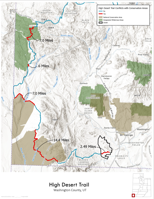
The trail is meant to drive ORV users and groups to some of the most remote areas of western Utah. In Washington County, the proposed route would thread a narrow passage between the designated Cougar Canyon and Slaughter Creek Wilderness Areas, continue through the Beaver Dam Wash National Conservation Area (NCA), and terminate in “Zone 6” of the Red Cliffs Desert Reserve near St. George—a world-class recreation area and important habitat for the threatened Mojave desert tortoise.
The BLM’s 15-day comment window ends on Tuesday, June 16. Please tell the agency to reroute the High Desert Trail away from wilderness, tortoise habitat, and the Beaver Dam Wash NCA.
 As currently proposed, the High Desert Trail would push a highly promoted ORV route through one of the most sensitive landscapes in southwestern Utah. Even though the trail does not technically enter wilderness (it follows a narrow “cherrystem” route between two wilderness areas), the National Environmental Policy Act (NEPA) requires the agency to take a hard look at real-world impacts to wilderness character, solitude, quiet, wildlife, and adjacent wilderness-quality lands.
The BLM’s Draft Environmental Assessment (EA) also makes clear that designation of this trail is intended to increase use. In fact, the agency expects use to increase by about 30 to 40 percent in the first one to three years. More promotion, more traffic, and more organized use will mean more noise, dust, user conflict, and greater pressure on nearby wilderness, cultural resources, and tortoise habitat.
Importantly, the BLM is considering two crucial reroutes—Colie Flat and Manganese Road—which would avoid bisecting wilderness areas, bypass most Mojave desert tortoise critical habitat, steer clear of the Beaver Dam Wash NCA, and mitigate user conflicts in the Red Cliffs Desert Reserve by relocating the route’s terminus at Manganese Wash, near Gunlock Reservoir, instead of in Zone 6.
This proposal is not just about a line on a map. The High Desert Trail is being planned as a continuous, promoted, point-to-point ORV route across western Utah, complete with signage, maps, kiosks, and coordinated permitting designed to increase travel and visitation. The BLM should not route this trail through wilderness-adjacent lands and some of the most ecologically sensitive parts of Washington County when a less damaging alternative is already available.
