The fight to protect public lands in Utah can be as bumpy and uneven as the terrain itself. The long struggle to protect Labyrinth Canyon is evidence of that. But the Labyrinth Canyon example also provides evidence that progress is possible when enough good people put their backs and hearts into the effort.
On September 28th, the Bureau of Land Management (BLM) finalized its motorized travel plan for the Labyrinth Canyon/Gemini Bridges area outside of Moab. The BLM’s plan is a huge victory for land protection. It is a victory more than 40 years in the making. This plan finally strikes a balance between motorized and non-motorized recreation. Importantly, it closed the off-road vehicle (ORV) routes that most significantly harmed this beloved canyon. Best of all, the plan protects the quiet, solitude, and wildness of this incredible place.
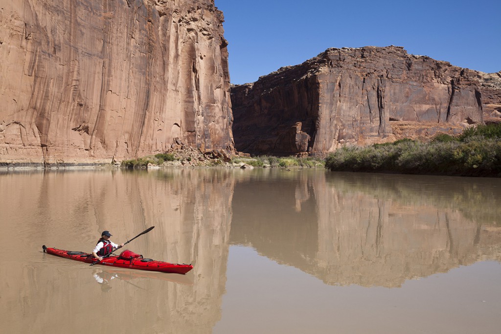
Nestled in the heart of redrock country, Labyrinth Canyon is a gem of the American West. Nearly 50 miles of the placid Green River flow through towering redrock canyons. This sublime stretch of river provides a multi-day flatwater river experience that is suitable for families and boaters of all experience levels. Labyrinth and its many side canyons, including Ten Mile, Hell Roaring, Spring, and Mineral encompass rare desert riparian areas, irreplaceable cultural sites, and significant wildlife habitat.
A Wilderness Outing to Remember
Since its founding, SUWA has been fighting to protect Labyrinth Canyon. When Utah Representative Wayne Owens first introduced America’s Red Rock Wilderness Act in 1989, he brought congressional colleagues to Utah to give them a taste of its incredible wild lands. The Utah Wilderness Coalition, with the help of local outfitter Dee Holladay and Holiday Expeditions, organized a canoe trip down Labyrinth Canyon for a dozen members of Congress. It was an eventful trip that included a torrential downpour and a hurried, middle-of-the-night tent relocation to higher ground, away from a swollen river that swept away entire cottonwood trees. Despite the unexpected excitement, those members of Congress, like so many before and after them, fell in love with this special place.
In the ensuing years, SUWA has worked tirelessly to protect the canyon. We fought short-sighted oil and gas leasing in the greater Labyrinth area, including leases the State of Utah proposed to sell beneath the bed of the Green River itself. We challenged oil and gas drilling and pipeline projects in the area, ultimately limiting their development. While a wide range of activities has imperiled Labyrinth Canyon, proliferation of ORVs has posed the most enduring threat. And over the years, the BLM has consistently failed in its duty to prevent damage from motorized vehicles.
Out of Control Motorized Use
In 1985, the BLM released a management plan for the Moab area, including Labyrinth Canyon. That plan opened virtually all of the Labyrinth landscape to cross-country ORV use, allowing vehicles to drive virtually anywhere, regardless of the harm to resources.
In response to the widespread damage cross-country ORV use caused, SUWA filed a statewide lawsuit in 1999 challenging the BLM’s failure to manage ORV use in Moab and beyond. The case made it all the way to the U.S. Supreme Court, which eventually rejected it on procedural grounds. But the lawsuit prodded the BLM to change its policies about when and where motorized use is appropriate. New travel plans began to restrict motorized vehicles to routes specifically dedicated to that use.
Despite hopeful changes, the agency still failed to control ORV use. In the waning days of the George W. Bush administration, the BLM released six resource management plans that smothered eastern and southern Utah with more than 30,000 miles of ORV routes. In the Labyrinth Canyon area, the agency designated roughly 1,200 miles of dirt roads and trails, including routes in riparian areas; fading, rarely used two-tracks; and an eight-mile route in the canyon bottom along the Green River. The dense network of routes made it nearly impossible to escape the sight and sound of ORVs.
SUWA and a coalition of conservation organizations challenged the six resource management plans, including the Moab plan. In 2013, a federal court found that those Bush-era travel plans violated the law by failing to minimize impacts to natural and cultural resources. The ensuing settlement agreement between the BLM, SUWA and our partners, and ORV groups, required the agency to rewrite travel plans with more than just motorized users in mind.
Changing Times
Events in 2019 were a game changer: Congress designated the west side of Labyrinth Canyon as wilderness and the river corridor itself as a scenic river under the Wild and Scenic Rivers Act. The east side of the canyon, however, remains unprotected. As a result, the quiet and solitude abundant along one shore is often shattered by the noise and dust of ORVs racing along the other riverbank, up and down side canyons, and along canyon rims. Vehicle tracks continue to cut through riparian vegetation and spread out across the riverbanks.
In the decades of fighting ORV mismanagement in Utah, the conditions have changed. ORV use has exploded. There are now more than 200,000 ORVs registered in Utah; thousands more are trailered in from out of state every weekend. Plodding jeeps have given way to dirt bikes and the now-ubiquitous “side-by-sides.” These vehicles are faster, louder, and more capable of penetrating deep into remote areas than ever before.
A New Opportunity
Those who cherish this stretch of river applauded the idea of a new Labyrinth Canyon travel plan. It offered the BLM the chance to correct decades of mismanagement and harmonize land management on both sides of the Green River.
Throughout the BLM’s multiple public comment periods for the Labyrinth Canyon/Gemini Bridges travel plan, public land lovers called on the agency to get motorized use under control. River guides and outfitters in Moab highlighted the unique visitor experience that floating this section of the Green River provides. River runners from around the country recounted their experiences floating the canyon, including the jarring sounds of ORVs that can reverberate off rock walls and carry for miles. Even the Grand County Commission asked the BLM for more balanced management (Grand County encompasses the planning area). More than 4,500 SUWA members and supporters asked the agency to preserve for future generations a fragile and vitally important riparian ecosystem, to protect irreplaceable cultural sites, to enhance wildlife habitat, and to save precious wilderness.
The BLM’s new travel plan does just that. It closes routes in side canyons where ORVs have caused well-documented damage to cultural sites and riparian habitat. It closes the route stretching eight miles along the Green River itself. The plan also removes unnecessary and redundant routes throughout the planning area to reduce some of the overwhelming impacts from motorized use.
The plan maintains motorized access to the Green River. It maintains access to spectacular overlooks. It maintains access to trailheads and recreation opportunities. But it also allows the countless hikers, river runners, climbers, canyoneers, campers, and nature lovers to experience this area away from the sight and sound of ORVs. It strikes a thoughtful balance between motorized and non-motorized recreation while also protecting precious natural resources. In short, it’s a motorized travel plan that finally does justice to this incredible landscape.
The Fight Continues
As with all public land fights in Utah, success requires continued vigilance and persistence. Unhappy with having only 800 miles of motorized vehicle routes in the Labyrinth area and thousands more in the greater Moab area, several ORV groups and the State of Utah appealed the BLM’s balanced decision to the Interior Board of Land Appeals. Motorized vehicle groups have also filed a lawsuit in federal court and are seeking an emergency injunction to block the plan from being implemented.
Precisely because the path to land protection can be rocky and arduous, it’s important to rejoice in the wins. Today, we celebrate the protection of Labyrinth Canyon. Tomorrow, we continue the fight to ensure that this protection endures.
—Laura Peterson
Upcoming Travel Plans
Though the Labyrinth Canyon plan is across the finish line, the Bureau of Land Management (BLM) must still complete eight more travel plans in Utah over the coming years, covering more than 5 million acres. Just as was the case in Labyrinth, these plans are critical in determining where motorized vehicles are—and are not—allowed to travel in some of Utah’s most remote and spectacular redrock country.
In the next year, the BLM will be working on a plan for the greater San Rafael Swell. That plan encompasses newly-designated wilderness areas as well as the San Rafael Swell Recreation Area. Outside of Utah’s national monuments, the Swell is one of the most well-loved areas of Utah’s backcountry. The agency also anticipates completing a travel plan for the Henry Mountains and Fremont Gorge area. Reaching from Capitol Reef National Park on the west to the Dirty Devil River and Glen Canyon National Recreation Area on the east, this varied landscape includes stunning alpine peaks, narrow redrock canyons, and the moon-like badlands.
Thoughtful travel planning in both areas will be critical to ensuring their preservation. And public input on these plans will be every bit as crucial as it was with the Labyrinth plan. Stay tuned for more information on how to get involved.
The above first appeared in the Autumn/Winter 2023 issue of our Redrock Wilderness newsletter. Become a member to receive our print newsletter in your mailbox 3 times a year.
