Sometimes to really understand an issue, you need to take a step back and look at the bigger picture. In the Bureau of Land Management’s (BLM) travel planning process, it is easy to get lost in the details: how many miles of off-road vehicle (ORV) routes will be designated in a given travel plan, which specific routes will be open or closed to motorized vehicles, has the BLM followed the spirt and the letter of the law in preparing its plan. Details definitely matter (trust us, we obsess over them), but what is really at stake is the protection of some of Utah’s most iconic landscapes.
In late October, the public comment period for the Labyrinth Rims/Gemini Bridges Travel Management Plan closed. This area, wedged between the Green River and Highway 191 just north of Moab, has long been a popular destination for an array of recreational user groups. The area’s unobstructed views, towering redrock cliffs, and Green River corridor provide endless opportunities for hikers, river runners, canyoneers, climbers, bikers, and campers.
However, the area has also experienced a dramatic increase in motorized recreation over the past decade. ORV noise and dust disproportionately impact other public land users as an ever-increasing number of ORVs traverse a maze of motorized vehicle routes that slice up the landscape in every direction.
This dense web of motorized routes is a result of the BLM’s 2008 resource management plan, produced by the agency’s Moab field office. It was one of six pushed out at the end of the George W. Bush administration.
Faster, Louder, More Intrusive
That collection of plans smothered southern and eastern Utah with 30,926 miles of ORV routes. In the 14 years since the BLM released those destructive plans, ORV use in Utah has exploded. New ORVs are faster, louder, and more capable of reaching deeper into remote areas than ever before. ORV riders have taken full advantage of these poorly-
developed plans. ORVs traverse virtually every wash and linear feature that can be located on a map (and some that can’t). In too many cases the damage they cause to natural and cultural resources is irreparable.
On the eastern rims of Labyrinth Canyon, ORV damage is evident. A tangle of routes crisscrosses its way over the landscape in every direction. Within the 304,000 acres of the Labyrinth Rims/Gemini Bridges Travel Management Area, there are roughly 1,200 miles of designated ORV routes. More than 94 percent of the landscape lies within a half-mile of a route, and 99.5 percent of the area is within a mile of a designated route. As a practical matter, it’s nearly impossible to escape the sight and sound of ORVs.
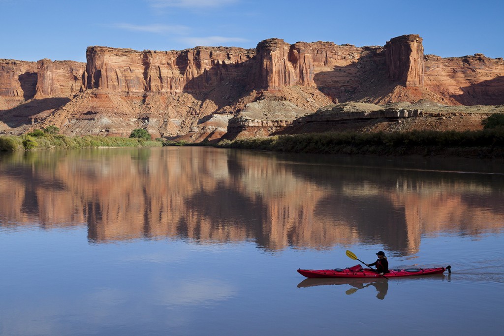
Yet, while the eastern rims of Labyrinth Canyon are blanketed in routes, the western rims are almost completely devoid of them. The Labyrinth Canyon Wilderness, designated by Congress in 2019, may be best experienced by a float trip on the Green River. The flatwater section of the river meandering through Labyrinth Canyon is a designated Wild and Scenic River. It offers recreationists of all ages and abilities the opportunity to experience incredible scenery, cultural sites reflecting thousands of years of human history, and an unparalleled multiday float through wilderness.
But the quiet and solitude abundant along one shore is often shattered on the other by the noise and dust of ORVs racing along the riverbank, up and down side canyons, and along canyon rims. Vehicle tracks cut through riparian vegetation and spread out across the riverbanks, weaving in whatever direction riders choose.
The Moment for Change
The BLM has a unique and immensely valuable opportunity before it. The Labyrinth Rims/Gemini Bridges travel plan is one of 11 the BLM is required to rewrite as part of a 2017 settlement agreement between SUWA-led conservation organizations, the BLM, and ORV groups to resolve litigation over the Bush-era plans. These plans will determine where motorized vehicles may legally travel on more than 6 million acres of BLM-managed land. The plans must minimize ORV-damage to natural and cultural resources, wilderness values, and other public land users. They will dictate which of those 6 million acres of public land will be carved up with vehicle routes and which will be preserved.
With this forthcoming travel plan, the agency has the chance to correct decades of mismanagement and harmonize land management on both sides of the Green River. The BLM has the opportunity to complete the protection of Labyrinth Canyon: to preserve for future generations a fragile and vitally important riparian ecosystem, to protect irreplaceable cultural sites, to enhance wildlife habitat, and to save remaining wilderness.
Throughout the BLM’s public comment period for the Labyrinth Rims/Gemini Bridges travel plan, public land lovers called on the agency to do just that. River guides and outfitters in Moab highlighted the unique visitor experience floating this section of the Green River provides and asked the BLM to protect the canyon’s solitude and serenity. River runners from around the country related their experiences floating this unique canyon, recounting the jarring sound of ORVs that can reverberate off canyon walls and travel for miles. Even the Ground County Commission (Grand County is the Utah county that encompasses the planning area) asked that the agency set Labyrinth Canyon aside for quiet, non-motorized recreation. More than 4,500 SUWA members and supporters demanded protection for this special place.
Beyond Labyrinth Canyon itself, the greater Labyrinth Rims and Gemini Bridges area suffers from the same ORV mismanagement that prioritizes motorized vehicle recreation at the expense of natural and cultural resources and other public land users. Many currently designated routes head off in straight lines to nowhere, clear evidence that they were originally punched into the wild redrock landscape as seismic lines and built as a part of oil and gas exploration decades ago.
Other routes braid through washes or proceed haphazardly around obstacles. Some routes are lightly used and barely visible, with nature well on its way to reclamation. ORV use on many other routes in the area is causing significant and well-documented damage to cultural sites, native vegetation, riparian resources, sensitive soils, and wildlife habitat.

A Clear if Imperfect Choice
When the BLM released a draft travel plan for the Labyrinth Rims and Gemini Bridges area in September, it analyzed four alternative travel networks. Only one of those—Alternative B—would protect Labyrinth Canyon itself and make any meaningful change to ORV management throughout this special place (see map aboee). Alternative B would still permit ORV travel on nearly 700 miles of routes such that more than 80 percent of the area would be within a half mile of a designated route. Alternative B would allow meaningful opportunities to access and experience these lands from a motorized vehicle. But it would also allow the countless hikers, river runners, climbers, canyoneers, campers, and nature lovers to experience this area away from the ubiquitous sight and sound of ORVs. It would protect precious natural resources under increasing pressure from years of drought; it would preserve cultural sites that continue to be damaged by motorized vehicles; and it would create some balance between ORV use and every other public land use.
The BLM is at a crossroads. It can perpetuate the sacrifice of the Labyrinth Rims and Gemini Bridges area to excess motorized recreation or it can take a step back, recognize what is at stake, and select Alternative B to protect this sublime landscape for decades to come. Labyrinth Canyon deserves no less.
—Kelsey Cruickshank and Laura Peterson
