The Bureau of Land Management (BLM) is in the process of deciding where motorized vehicles will be allowed to operate on more than six million acres of public lands in eastern and southern Utah. And while travel management planning may not sound very exciting, there is an easy way to emphasize its critical importance: the use of off-road vehicles (ORVs) in Utah has nearly doubled in the last 15 years.
The BLM’s planning process will designate motorized access routes to trailheads, scenic overlooks, and other recreation opportunities. These routes are largely uncontroversial. But the process will also determine the fate of the thousands of miles of wash bottoms, two-tracks, cow paths, and lines on a map that the agency contends are motorized vehicle routes. These designations could have significant impacts on Utah’s natural and cultural resources. Many of the supposed “routes” do not exist on the ground or are being naturally reclaimed. If they get any use at all, it is often illegal use by certain types of ORVs, including all-terrain vehicles (ATVs), utility task vehicles (UTVs or side-by-sides), and dirt bikes.
Today, more than 195,000 ORVs are registered in Utah alone. That figure does not include the tens of thousands of ORVs that out-of-state recreationists haul to the redrock every year.
While these machines undoubtedly provide outdoor recreation for some, they can have a disproportionately large impact on public land resources and on the experiences of other recreationists. ORVs cause stream erosion and water pollution, exacerbate dust and soil erosion, harass wildlife and fragment habitat, and damage cultural sites. Because of the damage ORVs inflict on sensitive resources, it is imperative that their use be carefully planned and reasonably managed.
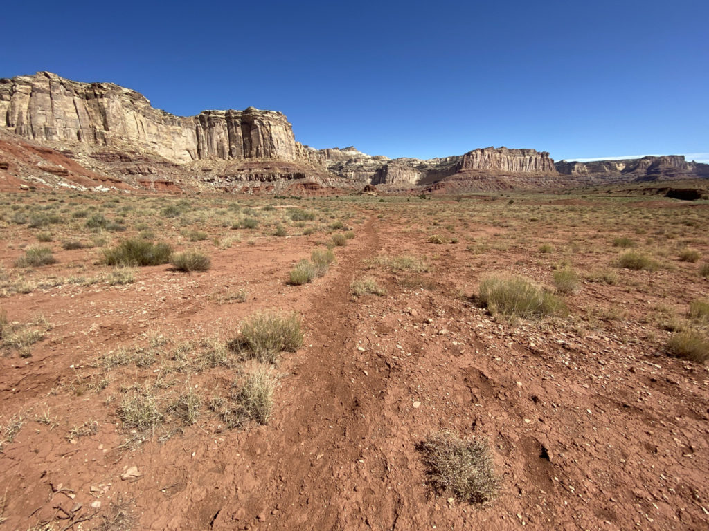
The BLM’s planning effort will ultimately determine where motorized vehicles will be allowed to travel in some of Utah’s most stunning and remote wild places, including the Dirty Devil, the San Rafael Swell, and Labyrinth Canyon.
How We Got Here
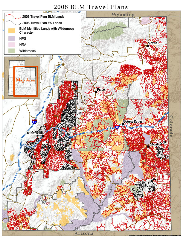
In the waning days of the George W. Bush administration, the BLM released six resource management plans to guide the administration of 11 million acres of public lands spanning much of eastern and southern Utah. Those plans smothered Utah’s public lands with a dense web of routes, ultimately designating 30,926 miles for motorized vehicle use (see map at right).
 Media outlets ranging from the Salt Lake Tribune to the New York Times decried the excessive designation of ORV routes and the BLM’s prioritization of ORV use at the expense of basically every other value on our public lands, including cultural and natural resources. Designated routes plow directly through cultural sites considered sacred by Native Americans and fragment wildlife habitat valued by Utah’s hunters and non-hunters alike. The Bush-era plans also exacerbated conflicts between motorized and non-motorized public land users.
SUWA and its conservation partners challenged those plans in federal court. In 2013, the court found that the travel plan for the BLM’s Richfield field office—the first to be considered—violated the law by failing to minimize impacts to natural and cultural resources. Following our court victory, the SUWA-led conservation groups entered into negotiations to resolve our claims against the remaining travel plans.
Under the ensuing settlement agreement between the BLM, conservation organizations, and ORV groups, the BLM is required to rewrite travel plans for 11 travel management areas over the course of eight years. As it prepares these new plans, the agency must engage in a transparent process that expressly considers the impacts that motorized route designations pose to wilderness-quality lands, sensitive natural resources, and cultural resources. The agency must also minimize impacts to those unique resources in its designation of routes.
Why This Matters
Much has changed in the decade-plus since the BLM released its irresponsible travel plans. Visitation has skyrocketed—fueled by the state’s unrelenting tourism advertising campaign and the rise of social media—and shows no sign of diminishing. At the same time, many of these visitors are riding ORVs designed to go more places faster than ever before. We are also grappling with the climate crisis, which only compounds the impacts motorized vehicles have across the landscape. Precisely because of these challenges, thoughtful and deliberate travel planning is critical.
The travel plans offer the BLM a second chance to get things right. Instead of catering to ORV interests, the agency can develop reasonable, manageable, and forward-thinking blueprints that preserve the backcountry and minimize damage while allowing public access where appropriate.
Places at Risk
By the terms of the settlement agreement, the BLM has until 2025 to complete 11 new travel plans across five field offices. So far, the agency has completed two: the San Rafael Desert plan (Price field office) and the Canyon Rims plan (Moab field office), discussed below. That leaves nine to be completed:
• San Rafael Swell (Price field office)
• Nine Mile Canyon (Price and Vernal field offices)
• Dinosaur North (Vernal field office)
• Book Cliffs (Vernal field office)
• Henry Mountains/Freemont Gorge (Richfield field office)
• Labyrinth Rims/Gemini Bridges (Moab field office)
• Dolores Triangle (Moab field office)
• Trail Canyon (Kanab field office)
• Paunsaugunt Plateau (Kanab field office)
The remaining plans encompass some of Utah’s most remote and spectacular wild lands. From the sinuous slot canyons of the San Rafael Swell and the soaring redrock buttes of Labyrinth Rims/Gemini Bridges to the rugged ridges of the Book Cliffs, the travel plans contain prime wildlife habitat, irreplaceable cultural sites, and immensely popular backcountry recreation areas.
A Fork in the Road
The two completed plans—San Rafael Desert and Canyon Rims—represent very different approaches to travel planning. Which of the two the agency embraces as a model for the next nine will tell us whether the BLM intends to double-down on off-road vehicle damage or finally institute balanced motorized vehicle management in redrock country.
BLM Takes Wrong Turn in Green River District
The San Rafael Desert travel management plan—the only plan finalized during the Trump administration—was predictably terrible. Released in August 2020, the plan inundated the remote and stunning San Rafael Desert with ORV routes, more than doubling the route mileage from 300 to 766. By its own admission, the BLM chose to “emphasize maximum mileage available for [ORV] recreation.” True to form, the agency designated virtually every wash bottom and line on a map as open to ORVs.
SUWA and The Wilderness Society have challenged the BLM’s destructive and illegal San Rafael Desert travel plan in federal court. That litigation is ongoing.
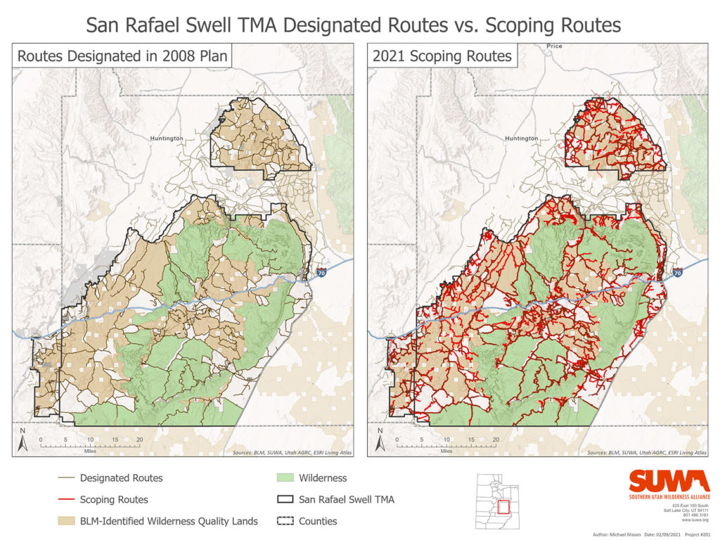
The BLM’s Green River District, which encompasses the Price and Vernal field offices, appears to be especially committed to sacrificing every acre of Utah’s public lands to ORV travel. Beyond the San Rafael Desert travel plan, the district has released initial scoping maps for the San Rafael Swell and Book Cliffs travel plans. Rather than instituting some balance in ORV management, the BLM is considering designating over 1,000 miles of new routes in the San Rafael Swell (see map on page 8) and over 700 miles of new routes in the Book Cliffs.
Enshrining any of these new routes in the travel plans would simply make a bad situation even worse and further prioritize ORV use at the expense of wildlife, wilderness, and other recreationists. Adding these new routes would also violate the BLM’s legal duty to minimize damage to natural and cultural resources both on a route-by-route basis, and at the broader plan level.
To call the BLM Green River District’s travel planning to date disappointing would be a massive understatement. If the agency continues down this path, it will forever change Utah’s wild places and will ensure endless litigation.
Canyon Rims: A Step in the Right Direction
While the travel planning in the BLM’s Green River District has been unacceptable, the Moab field office’s Canyon Rims travel plan offers a more sensible and balanced approach.
The Canyon Rims travel plan covers 91,000 acres of BLM-managed land in northern San Juan County, including the well-known and scenic Needles, Canyonlands, and Anticline overlooks. In its final plan, released this past May, the agency used the 2008 travel plan as the “ceiling” for motorized route designations. Rather than attempting to add countless two-tracks and illegally-traveled routes to the already excessive motorized network, the BLM closed about 46 miles of unnecessary routes. Many had naturally reclaimed or are in the process of naturally reclaiming due to lack of use. Others are redundant to routes designated in the plan. The agency could have—and should have—closed more routes, but the plan was nevertheless a step in the right direction.
Travel Plan Spotlight: Labyrinth Rims/Gemini Bridges
The Labyrinth Rims/Gemini Bridges area outside of Moab encompasses the internationally-recognized Labyrinth Canyon section of the Green River as well as its many side canyons, including Hell Roaring and Ten Mile. The area’s unobstructed views, soaring redrock cliffs, and Green River corridor provide endless opportunities for hikers, river runners, photographers and campers. The area is also a prime example of the excesses of the BLM’s 2008 travel plans.
In its last go-round, the agency smothered the area with 1,232 miles of motorized vehicle routes. Currently, 94 percent of the lands in the Labyrinth Rims/Gemini Bridges area are within half a mile of a designated off-road vehicle route while less than 1.5 percent are two miles or more from a designated route.
In its upcoming travel plan, which the BLM hopes to complete by 2023, the agency must significantly reduce the motorized route network in this area to protect public land resources and balance motorized and non-motorized recreation. Visit www.suwa.org and suscribe to our email list to stay informed and make your voice heard.
A Path Forward
As it works to complete the remaining nine travel plans, the Utah BLM should ensure that the 2008 plans—which a federal court has already ruled were illegal and failed to minimize damage to natural and cultural resources—represent the upper limit of motorized vehicle routes the agency will designate. Instead of straining to add every wash bottom to the motorized vehicle network, the agency should focus on removing duplicative routes, those routes that nature has reclaimed or is reclaiming, routes that are non-existent on the ground, and routes that damage sensitive resources.
This travel planning process is the BLM’s best chance to shape the public’s experience of Utah’s remarkable public lands. Rather than viewing this process as a burden, the BLM should take advantage of this opportunity to protect our shared heritage.
SUWA will continue to hold the BLM accountable and do our best to ensure that the agency completes and implements plans that do justice to these landscapes and cultural sites.
—Laura Peterson
(From Redrock Wilderness newsletter, Summer 2021 issue)
