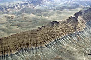
 These badlands near Sand Wash in Desolation Canyon will be littered with well pads and roads if the Gasco Project is approved as is. Photo courtesy of Bruce Gordon/Ecoflight. |
This is the last week to tell the Obama Administration to protect Desolation Canyon before it releases its decision on the potentially disastrous Gasco project.
Remember, this is the project that places at risk one of the lower 48’s largest unprotected roadless areas. The Bureau of Land Management’s current preferred alternative for this project would locate more than 200 wells inside of proposed wilderness surrounding Desolation Canyon. This destruction is needless, as the agency could instead select “Alternative E” and eliminate all wells inside of proposed wilderness while still allowing Gasco to drill over 1,100 wells.
Fortunately, thanks to the efforts of SUWA members and supporters, people are starting to take notice of this misguided project and the harm it could cause. Even the New York Times editorialized last week against this boondoggle. The Salt Lake Tribune has not once, but twice declared that this is not the way to do things.
Your voice makes a difference. Please take this opportunity to chime in and point the Obama administration in the right direction.
The BLM has announced that it plans to finalize its decision on the Gasco project after the close of a thirty-day waiting period, which ends on Monday, April 16. Please let Interior Secretary Ken Salazar know before then that you expect him to make the right decision and protect Desolation Canyon by selecting Alternative E.
While you are at it, make sure to sign our Change.org petition and tell your friends to take action to protect Desolation Canyon.
") Looking southeast from a bench off the Wrinkle Road — a Gasco well would be drilled in this approximate area under Alternative F.
Looking southeast from a bench off the Wrinkle Road — a Gasco well would be drilled in this approximate area under Alternative F.
")
Looking into Nine Mile Canyon (Nine Mile Creek) from the Sand Wash airstrip (no proposed wells visible, though drilling of proposed wells could be seen/heard from this location).
")
Sand Wash airstrip looking north to the Sand Wash put-in (no proposed wells visible, though drilling of proposed wells could be seen/heard from this location).
") Looking north/northwest from the Sand Wash airstrip (Sand Wash road leading to the river put-in below). Wells would be drilled atop the Bad Land cliffs (background) and on the western (left) edge of the Wrinkle Road in the photo.
Looking north/northwest from the Sand Wash airstrip (Sand Wash road leading to the river put-in below). Wells would be drilled atop the Bad Land cliffs (background) and on the western (left) edge of the Wrinkle Road in the photo.
")
Sand Wash airstrip looking west/northwest into the Gasco project area. Wells would be located on the top of the Bad Land Cliffs in the background and along the intermediate bench (Wrinkle Road).
")
Looking east from a bench off the Wrinkle Road — a proposed well would be drilled in this approximate location under Alternative F.
